

Electronics9 764›
- Computers2 697
- Headphones643
- TV, audio and home appliances4 610
- Security10
- Office equipment195
Home and garden3 153›
- For the home82
- For the garden315
- Tools656
Hobbies and modelling1 551›
Phones and accessories1 268›
- Cables21
Automotive1 249›
Sports and outdoors1 028›
Kids575›
Pets246›
Tattoo58
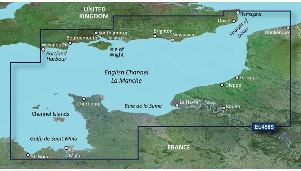
Garmin BlueChart g2 VEU456S - The Solent and Channel Islands chart
Offer listed on WystawCoChcesz.pl. The product is sold by the kupcochcesz.pl online shop.
Garmin BlueChart g2 VEU456S - The Solent and Channel Islands chart
The VEU456S card is a Garmin BlueChart g2 electronic marine chart for a chartplotter. It covers part of the coast of Great Britain and northern France, making it useful for sailors cruising the English Channel.
Chart coverage
On the British side, the chart covers the coast from Newhaven to Portland Harbour, including the Solent strait and the Isle of Wight. On the French side, coverage extends from Arromanches-les-Bains to Saint-Brieuc, including Saint-Vaast-la-Hougue, Cherbourg, Saint-Malo and the Channel Islands.
Use
The chart is intended for compatible Garmin chartplotters that support BlueChart g2 cards and allows precise planning of sailing routes in this area, including harbor approaches and strait crossings. Detailed depth data and navigation markings make it easier to pilot a vessel safely on both the English and French sides of the Channel. The card comes as a physical microSD/SD medium and simply needs to be inserted into the appropriate slot of the plotter, with no extra software installation.
Specifications
| Catalog number | 010-C0800-00 |
| Manufacturer | Garmin |
| Format | microSD/SD card |
| Region | Great Britain (English Channel) and northern France |
- Kod producenta
- 010-C0800-00
- Producent
- Garmin
Product reviews
There are no reviews of this product yet. Be the first to add one.
Similar listings: Garmin BlueChart g2 VEU456S - The Solent and Channel Islands chart
See more →





Recently viewed
715,00 zł
Buy in the shop