
Electronics9 764›
- Computers2 697
- Headphones643
- TV, audio and home appliances4 610
- Security10
- Office equipment195
Home and garden3 153›
- For the home82
- For the garden315
- Tools656
Hobbies and modelling1 551›
Phones and accessories1 268›
- Cables21
Automotive1 249›
Sports and outdoors1 028›
Kids575›
Pets246›
Tattoo58
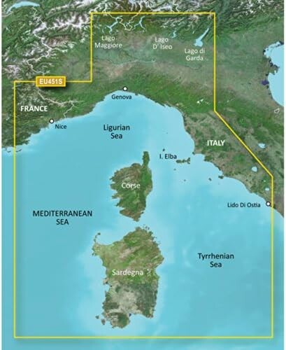
Garmin BlueChart VEU451S – nautical chart card, Ligurian Sea, Corsica, Sardinia
Offer listed on WystawCoChcesz.pl. The product is sold by the kupcochcesz.pl online shop.
Garmin BlueChart VEU451S – Ligurian Sea, Corsica and Sardinia
The Garmin BlueChart VEU451S card is an electronic nautical chart for Garmin plotters and chartplotters, covering the Ligurian Sea and the waters around Corsica and Sardinia. The chart contains detailed bathymetric data, markings of ports, marinas, and the main shipping routes of this region of the Mediterranean.
Use
The card is intended for sailors and powerboaters planning cruises along the Italian coast of Liguria and between Corsica and Sardinia. After inserting it into a compatible Garmin plotter, the user gets access to a detailed navigation chart of the region without having to download additional data online.
Compatibility
The BlueChart VEU451S chart works with selected Garmin plotters and chartplotters that support cards of this series, which lets you extend your navigation coverage to another region of the Mediterranean. Before buying, it is worth checking the card's compatibility with your device model. The card format allows quick installation without updating the plotter's software, which makes it easier to prepare the vessel for a cruise even before leaving port.
Specifications
| Card designation | VEU451S |
| Catalog number | 010-C0795-00 |
| Region | Ligurian Sea, Corsica, Sardinia |
| Type | Garmin BlueChart nautical chart card |
- Kod producenta
- 010-C0795-00
- Producent
- Garmin
Product reviews
There are no reviews of this product yet. Be the first to add one.
Similar listings: Garmin BlueChart VEU451S – nautical chart card, Ligurian Sea, Corsica
See more →


Recently viewed
1 402,00 zł
Buy in the shop